A Temple That Started a Fire Between Two Nations
一座寺廟引發兩國的砲火
Just a few days ago, Thailand and Cambodia had another clash on their border. The place is not new: Preah Vihear Temple. This ancient temple stands on a high cliff and was once just one of many temples from the Angkor period. But now, it feels like a time bomb of history for both countries. For Thai people, it was land they used to control. For Cambodians, it is a sacred place left by their ancestors. This is not only a fight for land—it’s a fight for the memory of the land.
就在前幾天,泰國與柬埔寨的邊境再度傳出交火的消息。地點不陌生——柏威夏寺。這座坐落在高聳斷崖之上的千年古剎,原本只是眾多吳哥時期遺址中的一處,如今卻幾乎成了兩國歷史記憶的火藥庫。對泰國人來說,那是曾經實際控制的領土;對柬埔寨人而言,則是祖先留下的聖地。這場紛爭要爭奪的不只是領土,而是關於這片土地的記憶主導權。
Borders Are Never Still
變動的邊界
To understand the conflict, we need to go back to the 11th century and the Khmer Empire. Preah Vihear and Ta Moan Thom were important temples built during the Angkor era. They were in the north of Cambodia, near the mountains.
The Khmer kings used these temples to show their power and mark their borders. But in the 14th century, the empire weakened. Siam (now Thailand) grew stronger and took control of this area. For Thailand, this land became part of their kingdom. For Cambodia, it was a painful memory of being invaded.
要理解這場衝突,得先回到公元11世紀的高棉帝國。柏威夏寺與塔莫安通寺同為吳哥王朝的大型宗教建築,分別位於今天的柬埔寨北部與邊境山脈中。它們是高棉王朝的宗教場域與權力投射的象徵,高棉王朝以這些寺廟標記王國邊界,向天神宣示主權。但帝國盛極而衰。14世紀起,高棉逐步喪失對西部的掌控,而來自西邊的暹羅崛起。阿瑜陀耶王朝數次入侵吳哥,也逐漸掌控今日柬泰邊境地區。對泰國來說,這些地方自此就是暹羅的一部分;但對柬埔寨人而言,那只是祖國遭外族侵略的百年恥辱。
Colonial Maps Decided the Border
殖民者的地圖說了算
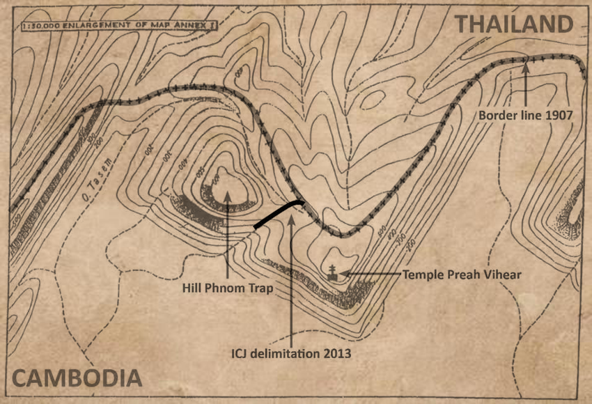
In the late 1800s, France came to Southeast Asia and made Cambodia a French colony. They forced Siam to sign treaties in 1904 and 1907 to fix the borders. The treaties said the border should follow the “watershed”—the highest point in the mountains. Preah Vihear was on a cliff, so it should have been on the Thai side. But French maps showed it in Cambodia. Why? The only road to the temple is from Thailand. Also, the watershed line on the map didn’t match the real land. The French used tools like theodolites and chains, but the jungle and cliffs made it hard to measure accurately. Thailand didn’t complain at first, but never really accepted the map. To them, it was drawn by a colonial power without fairness.
19世紀末,法國將柬埔寨納入法屬印度支那殖民地,並迫使暹羅在1904年與1907年簽訂條約,劃定兩國邊界。按照條約,邊界應以「分水嶺」為依據劃定。柏威夏寺座落在一處壯觀的懸崖頂端,地理位置極具戰略價值。雖然法國繪製的地圖上看似位於分水嶺以南、因此被劃入柬埔寨一側,但前往寺廟的唯一可通行道路卻在今日泰國境內。此外,法國測量隊所劃定的分水嶺也不完全符合實際地形,這使得邊界的合法性與合理性自始便存在爭議。法國使用如經緯儀與測距鏈等工具,但在熱帶叢林與峭壁地形中,準確性有限。當時仍稱暹羅的泰國雖未立即抗議,卻始終不認同那張地圖的正當性。
Two International Court Decisions
法理與情感的拉鋸:兩次國際判決
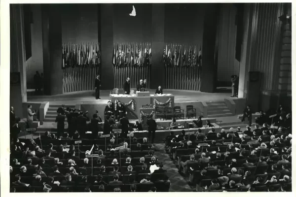
In 1962, the case went to the International Court of Justice (ICJ). The court gave Preah Vihear to Cambodia because Thailand didn’t protest the map earlier. This caused anger in Thailand. People burned Cambodian flags. They felt it was unfair—a colonial map used against modern sovereignty. In 2013, Cambodia asked the court again to decide who owns the land around the temple. The court said the area also belongs to Cambodia. After that, both countries sent more soldiers to the border. Small fights happened. The temple became the center of an old and painful problem.
1962年,雙方將爭議提交至國際法院。法院以「泰國當年未對地圖異議」為由,判柏威夏寺歸柬埔寨。泰國民間一片嘩然,甚至有人焚燒國旗抗議。對泰國人來說,這是殖民遺產對現代主權的壓制。2013年,柬埔寨再次請求法院釐清寺廟周邊主權,法院認定附屬地區亦屬柬埔寨。判決公布後,雙方軍事部署升級,多次發生小規模衝突,成為爭議未解的核心。
Textbooks and National Memory
教科書裡的國族記憶
In schoolbooks, the two countries tell very different stories:Thai textbooks say Preah Vihear was lost. They talk about how Siam ruled the area for a long time and suggest that the land was taken unfairly.
Cambodian textbooks call it a “heritage of the ancestors” and link it to Angkor Wat. The court’s decision is seen as justice finally served.
No one is completely wrong. They just look at the past in different ways. The temple has become a mirror, showing how each country remembers its own story.
這些遺址在兩國教科書中,承載著極不同的國族敘事:
泰國教科書多以「失土」論述柏威夏,強調暹羅王朝對該地區的長期統治,暗示是「被殖民者與國際體制奪走的主權」。
柬埔寨教科書則將柏威夏與吳哥窟並列為「祖先遺產」,強調高棉王朝的光榮與正義回歸。
都沒有錯,只是看向過去的方式不同。柏威夏成了一面鏡子,映照出兩個國家如何選擇回顧自己。
Two Kinds of Pain
兩種遺憾和委屈
Thailand feels sad because they controlled the area for many years, but lost it because of a colonial map. They also feel angry about unfair international rules.
Cambodia feels sad because this is their temple, but it was controlled by another country for so long. Even after winning twice in court, they still have to prove they are right.
Both sides believe they are right, but they cannot convince the other.
泰國的委屈在於:百年來實際管理的區域,因殖民地圖與國際判決失去控制。他們更憤怒的是國際體系的不公平。
柬埔寨的委屈則是:這是我們祖先的廟宇,卻長期由鄰國掌控。即使兩度勝訴,也要在國際與軍事壓力下不斷自證清白。
雙方都自認合理,卻無法說服對方放下。
Where Does History Begin?
從哪一段歷史開始說起?
Preah Vihear cannot speak for itself. People give it meaning.
If we ask: “Who owns this land?”
Maybe we should first ask: “From which point in history do we start counting?”
From the Khmer Empire? The Siamese Kingdom? The French colony? Or the UN court ruling?
Not only Thailand and Cambodia—many border problems in the world ask the same question: Where does history start? Who draws the line?
Preah Vihear is only one example. It shows that borders are not just lines on a map. They are about memory, history, and identity. To understand each other’s memory may be the first step toward dialogue.
柏威夏寺不會說話,是人們給了它歷史意義。
如果我們問:「這塊土地屬於誰?」
或許我們該先問:「我們要從哪一段歷史開始數起?」
從高棉帝國?從暹羅王朝?從法國殖民地?還是從聯合國判決那年?
不只是泰國與柬埔寨,世界上許多邊界爭議皆源於相同的問題:歷史從哪裡開始?誰有權定義那條線?
柏威夏寺只是其中一例,卻足以提醒我們,邊界不只是地圖上的線,更是歷史、記憶與身份的交會點。理解彼此記憶的來源,或許才是讓人們產生對話的起點。